


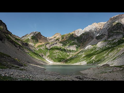
Video 019: from the Cirque du Fer-à-Cheval toward Lac de la Vogealle
Video 019 documents an Alpine hike from the Sixt-Fer-à-Cheval area toward Lac de la Vogealle. Haut-Giffre Tourisme publishes an itinerary to the refuge and lake with an indicative duration of 5 hours 30 minutes and 1,152 metres of positive elevation gain, with the same amount of descent on the return. The official description also highlights Pas du Boret, an exposed section fitted with cables and discouraged for hikers uncomfortable with heights; it recommends returning by the Bout du Monde route to avoid descending the same aerial passage.
These figures establish scale but do not prove that every second of the video follows the exact official GPX line. Mountain routes have variants and filming includes stops and editorial cuts. The dossier therefore separates the published reference route from the personal experience recorded by the camera.
Why 1,152 m ÷ 5.5 h would be a misleading climbing rate
The 5 h 30 figure describes the overall itinerary and the route is presented as an out-and-back journey. Directly computing 1,152 m ÷ 5.5 h would mix ascent with time spent on flatter terrain and descending. The useful lesson is methodological: a calculation is meaningful only when numerator and denominator refer to the same physical process.
Pas du Boret: a cable does not turn a hiking trail into a via ferrata
The official route calls Pas du Boret aerial and notes fixed cables. They assist progress on an exposed section, but their presence does not make the whole hike a via ferrata or justify improvising technical equipment. Comfort with exposure varies greatly between hikers, even when the underlying walking difficulty is described as moderate.
The recommended return through Bout du Monde is a good example of risk management through route choice. Avoiding a descent on an exposed section can be more comfortable after fatigue accumulates. Edited video rarely communicates the full physiological or psychological effect of hours on the trail.
A nature reserve of roughly 9,500 hectares spanning more than 2,000 vertical metres
The Sixt-Fer-à-Cheval / Passy national nature reserve covers roughly 9,500 hectares. The Haute-Savoie conservation organisation describes an altitudinal range from about 870 to 3,100 metres, a difference of more than 2,200 metres across the protected territory.
An altitude range that explains ecological diversity
3,100 m − 870 m = 2,230 m. This is not the elevation gain of the Vogealle hike. It is the vertical range of the reserve as a whole. Such a span allows montane forest, subalpine grassland, cliffs, limestone pavement, glaciers and high Alpine environments to coexist within one protected area.
A limestone massif where water both shapes and drains the landscape
Haut-Giffre is a high, wet limestone massif. Reserve material describes remnant glaciers, snowfields, springs, waterfalls, streams and lapiaz. Water travels over the surface but also enters fractures and slowly dissolves limestone, contributing to karst features such as caves, shafts and sculpted rock.
The Cirque du Fer-à-Cheval and its waterfalls make this hydrology spectacular. Yet not every visible waterfall should automatically be labelled a karst spring. Some are fed by ordinary streams, melting snow or surface runoff. Precise source attribution requires hydrological evidence rather than visual appearance.
Lac de la Vogealle: a seasonal destination rather than a fixed postcard
Haut-Giffre Tourisme notes that the lake’s water presence varies seasonally, with water generally indicated through late July. This is a useful reminder that a mountain lake can look very different depending on snowmelt, rainfall, drainage and the date of observation.
The lake is described as about twenty minutes beyond the refuge. That sounds short in isolation, but it comes after a substantial approach. In long mountain days, a final extension should be judged against remaining daylight, weather and the energy needed for a safe return.
Rich Alpine wildlife without over-identifying distant silhouettes
The reserve manager reports close to 940 plant species, numerous mammals and insects, and iconic Alpine animals including ibex, chamois, golden eagle and bearded vulture. This establishes the ecological richness of the territory, but it does not mean every small animal or bird in the footage can be named confidently.
Where visible diagnostic features are insufficient, the dossier therefore describes species known from the reserve rather than claiming a camera-based identification. That distinction is essential for turning natural-history enthusiasm into reliable documentation.
Verification workshop: unpacking 1,152 metres of positive ascent
Cumulative ascent of 1,152 metres means adding every uphill section along the route. It does not mean the path climbs continuously by 1,152 metres between two elevations. A descent in the middle followed by renewed climbing increases cumulative gain without changing the net start-to-finish elevation in the same way. This distinction is fundamental when reading an elevation profile.
The 5 h 30 duration is also an estimate, not a promise. A loaded group, photography stops, wet ground or hesitation at Pas du Boret can lengthen the day considerably. A fast walker may take less time. For safety planning, adding margin is more sensible than building the day around the theoretical minimum.
Exposure: technical difficulty and psychological difficulty are not identical
Pas du Boret illustrates an often-overlooked distinction. A section can be technically modest yet psychologically demanding because of open space below. A cable can increase objective support without removing fear. Discomfort with heights is therefore an individual variable that cannot be inferred from another person’s calm appearance in video.
The recommended return through Bout du Monde also shows that mountain routes can be asymmetric. The best way up is not always the best way down. Foot placement, visibility of holds and fatigue change with direction. A useful documentary page should explain this logic rather than treating a route as a simple line on a map.
Nature reserve: visitation and conservation are not necessarily opposites
The reserve presentation reports more than 300,000 visitors per year. This demonstrates that a strongly protected area can remain open to discovery. The challenge is to concentrate use on suitable trails, enforce rules and reduce disturbance to sensitive species. Hiking can therefore remain compatible with conservation when visitors accept the operating limits of the protected site.
A final check: altitude and weather margins compound each other
Long ascent, exposed terrain and changeable weather interact rather than acting independently. A hiker delayed on lower sections may reach Pas du Boret or the lake later than planned, when fatigue is greater and afternoon conditions have changed. Route planning should therefore include decision points: a time beyond which the refuge or lake extension is abandoned, a weather threshold that triggers retreat, and an alternative descent that avoids the exposed passage.
These are not instructions for one specific person but examples of how mountain risk is managed. The film can inspire the outing; a robust plan must still account for the group, season, current snow and the information published locally.
Sources and verification
- Davious03 Aventures — video 019, Sixt-Fer-à-Cheval and Vogealle: primary video source.
- Haut-Giffre Tourisme — Refuge and Lac de la Vogealle: time, ascent, Pas du Boret and route advice.
- Asters-CEN Haute-Savoie — Sixt-Fer-à-Cheval / Passy reserve: habitats, biodiversity, limestone relief and key figures.
- Haut-Giffre Tourisme — Lac de la Vogealle: lake context and seasonality.